Yao Li
  • About me(current)
  • Resume
  • Research
  • Photography
  • Music
  • About me

    Photo of me

    Yao Li is a postdoctoral researcher at the Department of Geographic Sciences, Univerisity of Maryland, College Park. Currently interested in the field of Health GIS, human mobitliy, dynamic simulation and visualization.

    Email: liyao@umd.edu

  • Education

    2016 - 2021 :   Univerisity of Maryland, College Park.   PhD
    Major :    Geographic Sciences

    2013 - 2016 :   Univerisity of Chinese Academy of Sciences.   Master
    Major :    Ecology

    2009 - 2013 :   Wuhan Univerisity.   Bachelor
    Major :    Remote Sensing Science and Technology

    Experiences

    2021 - present :   Postdoctoral Researcher for NIH and NSF projects .

    2017 - 2021 :   Research Assistant for NIH, NASA and Gates Foundation projects .

    2016 - 2017 :   Teaching Assistant for Department of Geographic Sciences, Univerisity of Maryland, College Park. .

    2013 - 2016 :   Research Assistant for NSFC (The National Natural Science Foundation of China) project : ‘Multi-scale dynamic simulation of grasshopper meta-population based on cellular automata ’.

    2013 - 2015 :   Field survey in Xianghuangqi County,Inner Mongolia, China.

    Software & Tools

    (frequency of use)

    ArcGIS

    ENVI

    QGIS

    Spark

    tech

    Programming

    (frequency of use)

    Python

    R

    Html

    JavaScript

  • Malaria exposure risk estimation

    A maximum entropy model was trained to estimate the distribution of P. vivax malaria for a period between January 2019 and April 2020, capturing estimated malaria occurrence for these provinces. A random simulation workflow was developed to make region-based case data usable for the machine learning approach. This workflow was used to generate a probability surface for the ecological niche regions. The resulting niche regions were analysed by occupation type, home and work locations, and work-related travel routes to determine the relationship between these variables and malaria occurrence. A one-way analysis of variance (ANOVA) test was used to understand the relationship between predicted malaria occurrence and occupation type.

    Related publication:
    1. Memarsadeghi, Natalie, Kathleen Stewart, Yao Li, Siriporn Sornsakrin, Nichaphat Uthaimongkol, Worachet Kuntawunginn, Kingkan Pidtana et al. "Understanding work-related travel and its relation to malaria occurrence in Thailand using geospatial maximum entropy modelling." Malaria Journal 22, no. 1 (2023): 1-11.

    migration surfaces
    Forest workers MVS

    Simulating human mobility for Malaria

    More details about human movement patterns are needed to evaluate relationships between daily travel and malaria risk at finer scales. A multi-agent mobility simulation model was built to simulate the movements of villagers between home and their workplaces in two townships in Myanmar. Mobility characteristics for different occupation groups showed that while certain patterns were shared among some groups, there were also patterns that were unique to an occupation group. Forest workers were estimated to be the most mobile occupation group, and also had the highest potential malaria exposure associated with their daily travel in Ann Township. In Singu Township, forest workers were not the most mobile group; however, they were estimated to visit regions that had higher prevalence of malaria infection over other occupation groups.

    Related publication:
    Yao Li, Kathleen Stewart, Kay Thwe Han, Zay Yar Han, Poe P Aung, Zaw W Thein, Thura Htay, Dong Chen, Myaing M Nyunt, Christopher V Plowe, Understanding spatio-temporal human mobility patterns for malaria control using a multi-agent mobility simulation model, Clinical Infectious Diseases, 2022;, ciac568, https://doi.org/10.1093/cid/ciac568

    Malaria parasites migration simulation

    Understanding the genetic structure of natural populations provides insight into the demographic and adaptive processes that have affected those populations. Such information, particularly when integrated with geospatial data, can have translational applications for a variety of fields, including public health. In this study, we developed a workflow to optimize the resolution of spatial grids used to generate EEMS migration maps and applied this optimized workflow to estimate migration of Plasmodium falciparum in Cambodia and bordering regions of Thailand and Vietnam.

    Related publications:
    1. Yao Li, Amol C. Shetty, Chanthap Lon, Michele Spring, David L. Saunders, Mark M. Fukuda, Tran Tinh Hien et al. "Detecting geospatial patterns of Plasmodium falciparum parasite migration in Cambodia using optimized estimated effective migration surfaces." International Journal of Health Geographics 19, no. 1 (2020): 1-11.

    2. Shetty, Amol C., Christopher G. Jacob, Fang Huang, Yao Li, Sonia Agrawal, David L. Saunders, Chanthap Lon et al. "Genomic structure and diversity of Plasmodium falciparum in Southeast Asia reveal recent parasite migration patterns." Nature communications 10, no. 1 (2019): 1-11.

    migration surfaces
    Screenshot of CTIS project website

    Data Engineering, API development and visualization for CTIS

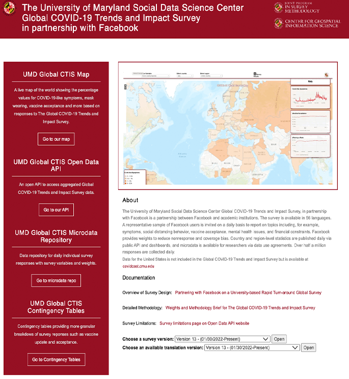
    I served as the main developer in Data Engineering and Visualization & API development for the project "The University of Maryland Social Data Science Center Global COVID-19 Trends and Impact Survey, in partnership with Facebook is a partnership between Facebook and academic institutions" (CTIS). The survey is available in 56 languages. A representative sample of Facebook users is invited on a daily basis to report on topics including, for example, symptoms, social distancing behavior, vaccine acceptance, mental health issues, and financial constraints.

    Related publications:
    1. Junchuan Fan, Yao Li , Kathleen Stewart, Anil R. Kommareddy, Adrianne Bradford, and Samantha Chiu. "Covid-19 world symptom survey data api." (2020).

    2. Kreuter, Frauke, Neta Barkay, Alyssa Bilinski, Adrianne Bradford, Samantha Chiu, Roee Eliat, Junchuan Fan, Tal Galili, Daniel Haimovich, Brian Kim, Sarah LaRocca, Yao Li , Katherine Morris, Stanley Presser, Tal Sarig, Joshua A Salomon, Kathleen Stewart, Elizabeth A Stuart, Ryan Tibshirani. "Partnering with a global platform to inform research and public policy making." In Survey Research Methods , vol. 14, no. 2, pp. 159-163. 2020.

    Soil mapping and fuzzy logical estimation

    We developed an enhancive predictive coefficient (EPC)-based soil mapping (EPSM) method. EPC integrates the contrasts of associated environmental principal component covariates by the weights of the covariates influencing a certain soil property. A member recruiting process was programmed to determine the calculating samples for an unknown site after conducting an uncertainty threshold (ut) test for all the sample sites. We applied the EPSM method to five data groups with different numbers and distributions of sample sites for prediction. The results showed that the EPSM method performs better than the soil-land inference model (SoLIM) method regardless the value of ut and thus can be used to estimate the soil property values well at most unknown sites. The method is especially valid when the unknown sites are spatially far from the sample sites and when sample sites are limited in number or spatially distributed at a local area. Our study suggests that the EPSM method is an effective PSM method that can be widely used in soil mapping

    estimation results

    Related publication:
    1. Yao Li, Na Zhang, Run-Kui Li, Cheng-Yu Liu, Jing Shen, and Yong-Cai Jing. "Soil mapping based on assessment of environmental similarity and selection of calculating samples." CATENA 188 (2020): 104379.

    Flow chart

    Other Publications

    1. Chen, Dong, Varada Shevade, Allison Baer, Jiaying He, Amanda Hoffman-Hall, Qing Ying, Yao Li, and Tatiana V. Loboda. "A disease control-oriented land cover land use map for Myanmar." Data 6, no. 6 (2021): 63.
    2. Zhang, Yajie, Gaopeng Li, Jing Ge, Yao Li, Zhisheng Yu, and Haishan Niu. "sc_PDSI is more sensitive to precipitation than to reference evapotranspiration in China during the time period 1951–2015." Ecological Indicators 96 (2019): 448-457.
    3. Zhang, Yajie, Yao Li, Jing Ge, Gaopeng Li, Zhisheng Yu, and Haishan Niu. "Correlation analysis between drought indices and terrestrial water storage from 2002 to 2015 in China." Environmental Earth Sciences 77, no. 12 (2018): 1-12.
    4. Yao Li and Na Zhang "Multi-scale spatial distributions of Oedaleus decorus asiaticus." Journal of University of Chinese Academy of Sciences 34, no. 3 (2017): 329.
    5. Zhang, Na, Yong-Cai Jing, Cheng-Yu Liu, Yao Li, and Jing Shen. "A cellular automaton model for grasshopper population dynamics in Inner Mongolia steppe habitats." Ecological Modelling 329 (2016): 5-17.
    6. Shen, J., N. Zhang, B. He, C-Y. Liu, Y. Li, H-Y. Zhang, X-Y. Chen, and H. Lin. "Construction of a GeogDetector-based model system to indicate the potential occurrence of grasshoppers in Inner Mongolia steppe habitats." Bulletin of Entomological Research 105, no. 3 (2015): 335-346.

  • Image
    Image
    Image
    Image
    Image
    Image
    Image
    Image